Dutch capital Amsterdam is midway through the Noord-Zuidlijn construction project, a new north-south metro line. To be designated Line 52, it will form an important transport artery through the central districts to connect suburbs north of the River Ij, currently served by frequent ferries, with the Amsterdam Zuid (south) transport interchange.
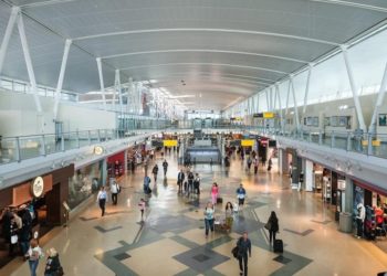
With this new link added to expanded InterCity services, the formerly named Zuid/WTC is well placed to serve the World Trade Centre and nearby RAI exhibition space.
Although at the forefront of initial planning for Amsterdam’s metro system dating from the 1960s, the eight-year north-south construction project only began in 2002 and is costing €1.7bn (excluding rolling stock), double the figure projected in 1996. Lines constituting the current Metro date from 1977, being a mix of dedicated metro and light rail.
The new line will provide more direct journey possibilities and provide connections with Amsterdam Centraal hub station and South/WTC railway station.
Parties involved in the design and planning are De Weger Architects, Ingenieursbureau Amsterdam (IBA), and Witteveen en Bos and VoF Stationseiland, with a consortium of constructors including Heijmans/Strukton, Strukton/van Oord and Max Bogl Nederland. International Transportation and Railway Services is responsible for the consultancy of operational management, drawing up timetables and providing specialist railway engineering advice.
THE PROJECT
The route is 9.8km long, of which a total of 6km will be underground. The stations are Buikslotermeerplein, Johan van Hasseltweg, Centraal Station, Rokin, Vijzelgracht, Ceintuurbaan, Europaplein and Zuid NS. Journey time for the entire route is expected to be 16 minutes. A four-minute interval service is planned for peak times, the frequency reducing to five-minutes during the day and ten in the evening.
INFRASTRUCTURE
The route follows both underground and overground alignments, running above ground to the banks of the River IJ before descending below the surface to reach Amsterdam Centraal station to interchange with other metro routes, the tram network and main line railway services within the Netherlands and onwards to Germany, Belgium and France.
As the route is too narrow for two parallel bores, the two running lines are being built above and below one another in a vertical alignment, between 20m and 35m below streets, the extensive canal system, bridges and sewers.
The new route is being bored from the central thoroughfare Damrak, and through the use of tunnel boring machines (TBM) allows the streets of Amsterdam to remain undisturbed as it works its way below from north to south.
The TBM covers approximately 8m in one day, with rails laid in each new partition for the work train, transporting the material and workers.
Because two tunnels are being constructed, two TBMs are needed. The two TBMs are not operating at the same time. When the first TBM has been operating for approximately three months, the second will be brought into the ground.
Both innovative and tried and tested construction techniques are being employed. Mindful of social unrest caused by previous Metro workings, the key goal is to minimise disturbance to the surrounding environment and to the residents of Amsterdam. Buildings are being monitored for disturbance during tunnel construction.
A downward construction method with diaphragm walls is employed to construct the underground stations. During excavation, cast in-situ concrete roof/floor slabs are used as the lateral support for the diaphragm walls. Starting from the top, excavation and concrete slab casting are carried out alternately.
Construction is being completed through open excavation for the shallow depth sections of the line, and a downward construction method with diaphragm walls or drilling method utilising tunnel boring machine for the deeper sections.
For construction of the underwater sections from 2009, pre-cast concrete boxes are being sunk into the river. For Centraal station, the Metro is part of a larger project that also includes replacing wooden foundation piles and making greater transport use of the river frontage.
ROLLING STOCK
The trains that will operate on the north-south line will have a maximum speed of 70km/h (47mph), with normal operation at 35km/h (22mph).
Stock for the latter will use the installed side-contact power supply, whereas overhead current collection will be the standard for the new line. The vehicles will have a 30-year life.
SIGNALLING AND COMMUNICATIONS
Safety on the new route is of paramount importance and as with the other metro routes in Amsterdam, the new line is expected to use twin aspect signals. Stairway access specifically for the emergency services will be installed, running tunnels will include walkways and escape tunnels every 350m. Passenger information displays will be provided at all stations alerting travellers to the proximity of the next arrival.
THE FUTURE
Part of the Zuidas (South Axis) development, Amsterdam Zuid’s importance to the city’s transport network was boosted by the 2006 completion of Utrechtboog, a chord that obviated changing at Duivendrecht. The new metro line will further encourage this process, with Amsterdam Centraal becoming less of a focus for long distance traffic.
Completion of Line 52 will increase the system route length to around 80km (50 miles). Other extensions under consideration include the new town of Ijburg, and a possibility that the north-south route could be extended to Schiphol Airport and Hoofddorp.


